
The lakes of Winter Park are a defining feature of our community and play an important role in the city’s environmental health. This dashboard offers detailed information on each lake, including water quality conditions, key characteristics, and current management initiatives.
Lake Bell
Lake Berry
Lake Chelton
Lake Forest

Lake Grace

Lake Killarney

Lake Knowles

Lake Maitland

Lake Mendsen

Lake Mizell

Lake Osceola

Lake Rose

Lake Spier

Lake Sue

Lake Sylvan

Lake Temple

Lake Tuscany

Lake Virginia

Lake Wilbar

Racquet Club Pond
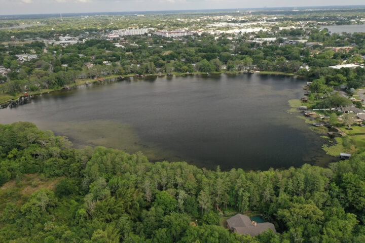
Lake Bell
Size 35 acres | Drainage Basin not determined | Average Depth 12 feet (approx.) | OHW Elevation 88.6 feet
General Information
Lake Bell is a water table lake. The water level is dependent on the elevation of ground water in the area. Ground water elevations are ultimately dependent on rainfall. There are no permanent surface inflows to Lake Bell, however it does receive flow from an adjacent borrow pit during high water conditions. When the water elevation is high, water flows out through a ditch and culvert system, into Lake Killarney to the south. The normal elevation of Lake Killarney is 82.8, nearly six feet below Lake Bell. The lake is shared with the Town of Eatonville with approximately 90% of the surface area lying within Winter Park.
Water Quality
Water quality in Lake Bell is primarily affected by stormwater runoff. In the late 90’s the lake was experiencing a noticeable decline in water clarity. Since 2004, however, the clarity of Lake Bell has been improving. Trend analysis for the period of record (1997 through 2008) shows no significant change in water clarity over that time.
Management Efforts
The City is in the process of installing baffle boxes and inlet baskets on all of the outfalls to the lake that lie within Winter Park. It is hoped that these new treatment systems will result in continued improvements in water clarity on the lake. Other activities on the lake include exotic plant control. The lake has had problems with hydrilla infestations in the past, periodic control is needed. Recently a small number of triploid grass carp were released into the lake to assist with the control of hydrilla re-growth. Residents around the Lake have formed the Friends of Lake Bell organization to help protect the lake. In addition to providing a voice of advocacy on public issues that could affect the lake, the group also performed a very successful re-vegetation of the lake which has help to improve water clarity conditions.
Access lakes data dashboard and select Lake Bell
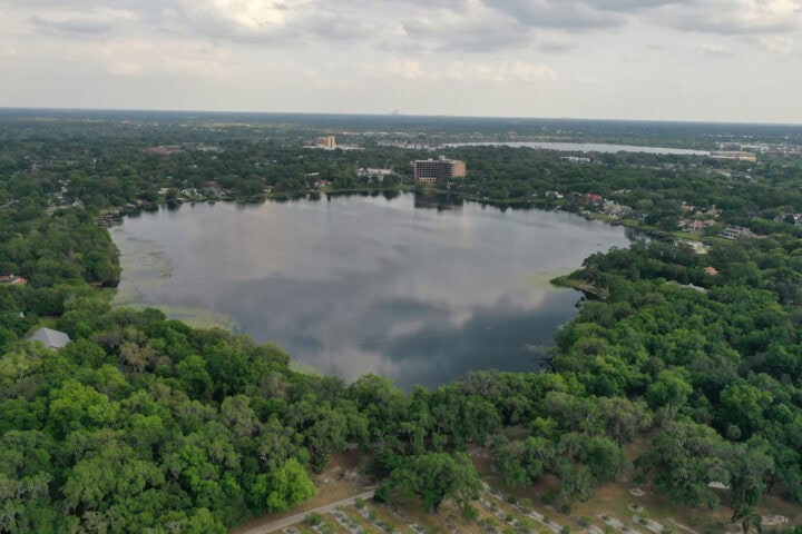
Lake Berry
Size 68 acres | Drainage Basin 441 acres | Average Depth 10 feet (approx.) | OHW Elevation 69.4 feet
General Information
Lake Berry has no permanent inflows and the water level is dependent on the elevation of ground water in the area. Water enters through ground water seepage and rainfall runoff. When the water elevation is high, water flows out through a ditched wetland system, into Lake Virginia. The normal elevation of Lake Virginia is 66.5, nearly four feet below Lake Berry. Recent development within the basin (the Windsong sub-division) was required to meet state and city stormwater treatment requirements. A portion of the basin, along the western shore of the lake, remains undeveloped. Approximately 30 percent of Lake Berry’s drainage basin either meets current stormwater treatment requirements, or is undeveloped.
Water Quality
Water quality in Lake Berry is primarily affected by stormwater runoff. Annual average Secchi disk transparency data from 1997 through 2008 show a positive statistical trend toward improving water clarity.
Management Efforts
The City has installed leaf traps in the past to help slow the amount of organic material entering the lake. Due to the large size of the outfalls, only one of the four traps has worked very well. The City has recently begun replacing the traps with more efficient retrofits. A large exfiltration system under Banchory Road (between Lakemont and Langholm) was constructed in 2008 and two additional treatment systems for Balmoral Road drainage are currently in design. Construction is tentatively scheduled for 2009. In the intervening period, the Lake Berry basin has been identified as a high priority basin for street sweeping activities. Other activities on the lake include exotic plant control. Water hyacinth and hydrilla are two noxious, non-native plants that occur in Lake Berry. Left untreated, these plants can render entire lakes impassable to boats. The lake is surveyed quarterly, and plants are sprayed as needed. The lakes division also responds to resident reports of nuisance plants in the lake.
Access lakes data dashboard and select Lake Berry
Lake Chelton
Size 4.6 acres | Drainage Basin 10 acres | Average Depth 12 feet (approx.) | OHW Elevation 79.2 feet
General Information
Lake Chelton is a sinkhole lake. The water level in the lake is dependent on groundwater levels, which are ultimately dependent on rainfall. Four stormwater outfalls convey runoff to Lake Chelton. There are no permanent surface inflows to, or outfalls from, the lake. The land between the lake and Lake Chelton Circle is a city park, and offers passive recreational opportunities for residents of the surrounding neighborhood.
Water Quality
Water quality in Lake Chelton is primarily affected by stormwater runoff. Annual average Secchi disk transparency data from 1997 through 2008 show no statistical trend. While water quality has remained good, there has been a measured decline in clarity over the period of record.
Management Efforts
Until recently, the city maintained leaf traps on all four outfalls to help slow the amount of organic material entering the lake. Due to the size of the outfalls, and the steep slopes, only one of the four traps worked very well. The traps were replaced with underground baffle boxes, which catch the leaves at the top of the bank, where velocities are much lower than at the lake. It is hoped the new systems will help improve water clarity in the lake over the next few years. Other management efforts conducted on the lake focus on the maintenance of shoreline vegetation, including the spraying and removal of exotic species, and the planting of native plants.
Access lakes data dashboard and select Lake Chelton
Lake Forest
Size 3.8 acres | Drainage Basin 35 acres | Average Depth 10 feet (approx.) | OHW Elevation 100 feet
General Information
Lake Forrest appears to be a geologically older, sinkhole lake. The water level in the lake is dependent on groundwater levels, which are ultimately dependent on rainfall. Four stormwater outfalls convey runoff to Lake Forrest. There are no permanent surface inflows to the lake. High water levels are controlled by a drainage well on the eastern side of the lake that conveys water to the aquifer once the lake level exceeds the control elevation (100.8 feet above sea level). There is no public access to Lake Forrest, and access for management purposes is over private property.
Water Quality
Water quality in Lake Forrest is primarily affected by stormwater runoff, although the timing of algae blooms indicate that internal cycling of phosphorus may be contributing significant loads during part of the year. Annual average Secchi disk transparency data from 1997 through 2008 show a positive statistical trend toward improving water clarity.
Management Efforts
The city maintains leaf traps on all four outfalls to help slow the amount of organic material entering the lake. Due to the size of the outfalls, and the steep slopes, the traps are only marginally effective, removing 20 to 70 percent of the leaf load. The efficiency of the traps is significantly affected by the size of the rainfall event (volume of runoff), and the amount of leaves on the ground at the time of the storm.
Other management activities include the installation of an aeration system in 2000 to reduce filamentous algae blooms, and infestations of floating plants such as floating fern (Salvinia rotundifolia) and duckweed (Lemna minor).
Access lakes data dashboard and select Lake Forest
Lake Grace
Size 1.3 acres | Drainage Basin 7 acres | Average Depth 9 feet (approx.) | OHW Elevation 100.8 feet
General Information
Like nearby Lake Forrest, Lake Grace appears to be a geologically older, sinkhole lake. The water level in the lake is dependent on groundwater levels, which are ultimately dependent on rainfall. Three stormwater outfalls convey runoff to Lake Forrest. There are no permanent surface inflows to the lake. Lake Grace is connected to Lake Forrest by a culvert, and high water levels are controlled by a drainage well on the eastern side of Lake Forrest that conveys water to the aquifer once the lake level exceeds the control elevation (101.6 feet above sea level).
Water Quality
Water quality in Lake Grace is heavily affected by stormwater runoff from within its own 7 acre drainage basin. Even though the basin seems small compared to some of the larger lakes, it is over five times the area of the lake. Statistical analysis of monthly Secchi disk data from 1998 through 2008 indicates no apparent trend in water clarity.
Management Efforts
The city maintains leaf traps on the two of the stormwater outfalls to help slow the amount of organic material entering the lake. Due to the size of the outfalls, and the steep slopes, the traps are only marginally effective, removing 20 to 70 percent of the leaf load (depending on the magnitude of the rain event). The third outfall receives treated runoff from a newer subdivision, and does not need a trap. The underground depth of the stormwater system in the Quail Hollow subdivision prevents the installation of cost effective stormwater treatment systems. The City has been experimenting with inlet baskets for leaf and debris removal, and may consider them for the Lake Grace basin if an efficient maintenance program can be developed for them.
Other management activities include the installation of an aeration system in 2000 to reduce infestations of floating plants, primarily the floating fern (Salvinia rotundifolia). Prior to the installation of the aeration system, it was common for 50 to 75 percent of the surface of Lake Grace to be covered with the small, floating plants. Controlling the plants required numerous herbicide treatments every year.
Access lakes data dashboard and select Lake Grace
Lake Killarney
Size 234 acres | Drainage Basin 1,070 acres | Average Depth 9 feet (approx.) | OHW Elevation 82 feet
General Information
Approximately 60 percent of the surface area of Lake Killarney lies within Winter Park. The remainder is in unincorporated Orange County, and management efforts are split between the county and the city. Water levels in the lake appear to be dependent on groundwater levels, but there may be undocumented, small magnitude springs in the lake. The water level in the lake does not fluctuate drastically during droughts, as other lakes in the area do. High water levels are controlled by drainage well in the southwest corner of the lake, and an
outfall structure located in a cove off of the north side of the lake. Water leaving Lake Killarney flows through pipes to Lake Gem in Maitland. From there the water flows through open channels to Park Lake and then to Lake Maitland.
Water Quality
Water quality in Lake Killarney is primarily affected by stormwater runoff. Annual average Secchi disk transparency data from 1998 through 2008 show a positive statistical trend toward improving water clarity.
Management Efforts
Ten of 13 stormwater outfalls on Winter Park side of Lake Killarney have leaf/debris traps to reduce the amount of organic material and sediments entering the lake. Two of the three large outfalls to the lake have additional treatment systems installed. The Gay Road outfall has a large baffle box structure to remove sediments, and the City of Winter Park recently completed a stormwater project that directs, dirty, first flush runoff water from a section of 17-92 into the ponds at Lake Island Park. This water previously ran, untreated, into Lake
Killarney through the Beachview Avenue outfall. Winter Park is currently working with Orange County to design a treatment system in the area around Minnesota Avenue and Clay Street that will provide treatment for a large commercial area that drains to Lake Killarney through an outfall at the end of Shoreview Avenue.
Access lakes data dashboard and select Lake Killarney
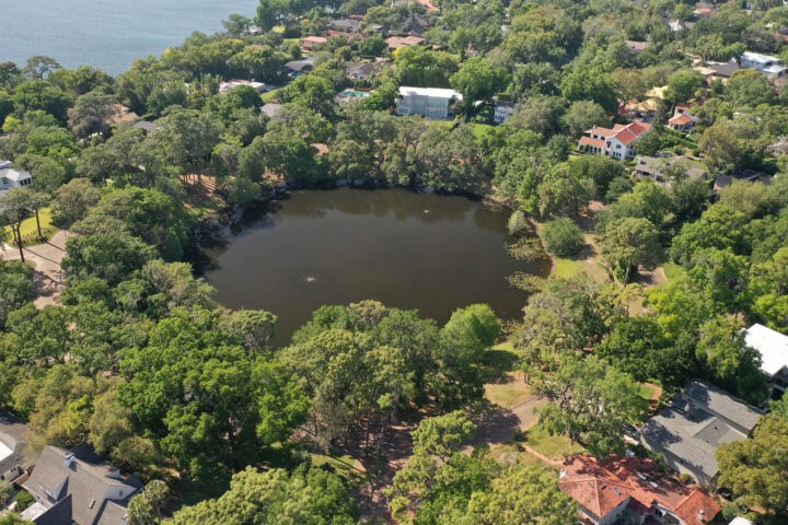
Lake Knowles
Size 7.7 acres | Drainage Basin 51 acres | Average Depth 15 feet (approx.) | OHW Elevation 75.9 feet
General Information
Lake Knowles is a small deep lake with consistently clear water. The nearly round shape and deep water of the lake indicate that it was most likely formed by a sinkhole. The fact that the water is generally very clear indicates that it is probably younger (in geological terms) than other sinkhole lakes in the area. Lake Knowles is a water table lake. Water levels in the lake are dependent on groundwater levels, which are ultimately dependent on rainfall. Recent droughts have resulted in extreme drops in the level of water in Lake Knowles. While the low water conditions are inconvenient, and sometimes unsightly, drought does help the lake cleanse itself of organic material. The wide water level fluctuations in Lake Knowles help to maintain the lake’s exceptional water quality.
Water Quality
Water quality in Lake Knowles is primarily affected by stormwater runoff. Annual average Secchi disk transparency data from 1998 through 2008 show a consistent condition of good water quality over the ten year period.
Management Efforts
The city maintains leaf traps on all eight outfalls to help slow the amount of organic material entering the lake. Because none of the outfalls are very large, and the slopes around the lake are not steep, the leaf traps on this lake work relatively well. The traps may eventually be replaced, but it is currently not a high priority.
The land between Lake Knowles and the surrounding streets is a city park, providing tranquil recreational opportunities to the surrounding areas. Lakes division crews maintain extensive stands of native aquatic plants around the lake. These plants add the natural beauty of the park, and attract wildlife, particularly birds, to the park. Periodic, drastic fluctuations in water levels significantly change the plant stand and affect wildlife viewing opportunities.
Access lakes data dashboard and select Lake Knowles
Lake Maitland
Size 451 acres | Drainage Basin 1374 acres | Average Depth 13 feet (approx.) | OHW Elevation 65.7 feet
General Information
Part of the Howell Branch Creek system, Lake Maitland is the lower most lake in the Winter Park chain of lakes. Approximately 75 percent of the surface area of Lake Maitland lies within Winter Park. The remainder of the lake is in the City of Maitland. Lake Osceola is the most immediate upstream lake in Winter Park, but Lake Maitland also receives surface flow from Lake Minnehaha and Park Lake, both of which are in Maitland. Water leaves Lake Maitland via Howell Branch Creek, and flows over a control weir at Howell Branch Road.
As with most lakes in this area, Lake Maitland is a water table lake, and its level is dependent on rainfall, surface flow and groundwater levels. Lakes Osceola and Minnehaha are accessible from Lake Maitland by navigable canal.
Water Quality
Water quality in Lake Maitland is strongly affected by two sources, stormwater runoff and flow from the three upstream lakes. Annual average Secchi disk transparency data from 1997 through 2008 show a positive statistical trend toward improving water clarity.
Management Efforts
A coordinated plant management program has been established between the City of Winter Park and the City of Maitland. Under this program the City of Winter Park performs plant management activities on the entire lake, and bills Maitland for work performed in their areas of the lake. Major plant control efforts focus on controlling exotic plants such as hydrilla and water hyacinth. Occasional control of native plants like pondweed is required to maintain boating access.
Stormwater retrofits currently in place on Lake Maitland include exfiltration systems at North Park Avenue, Sunnyside Drive and North New York Avenue. There are also CDS structures installed at McKean Circle and Green Cove Road (2 outfalls), Via Lombardi and North Park Avenue. Additional retrofits that are in the current five year plan include treatment systems for the outfalls draining the Dixie Parkway and Summerland Avenue areas.
Access lakes data dashboard and select Lake Maitland
Lake Mendsen
Size 5 acres | Drainage Basin 248 acres | Average Depth 6 feet (approx.) | OHW Elevation 81.1 feet
General Information
Lake Mendsen is a stormwater treatment pond. Mendsen was originally a joint research project between the Florida Department of Environmental Protection and the University of Central Florida designed to provide treatment for the drainage basin, for stormwater runoff, and pump discharge for irrigation use. A diversion box was installed, diverting stormwater from Lake Killarney, from Orlando Ave to provide flood control and be a water quality improvement for Lake Killarney. A drainwell is also in place on Lake Mendsen to mitigate flooding.
Water Quality
Water quality is primarily affected by stormwater. Aerators on the lake help in breaking down of excess nutrients.
Management Efforts
The city maintains two leaf traps to help slow the amount of organic material entering the lake. The land surrounding Lake Mendsen is MLK Park, maintained by the Parks and Recreation Department, a wide open park providing beauty and recreational activities.
The Lakes Division crew maintains native emergent vegetation along the shoreline and treat invasives. These native aquatic plants attract and provide habitat for wildlife in the park. Game fish is stocked into the lake to providing opportunities to new and experienced fishermen.
Access lakes data dashboard and select Lake Mendsen
Lake Mizell
Size 60.5 acres | Drainage Basin 258 acres | Average Depth 14 feet (approx.) | OHW Elevation 65.7 feet
General Information
Part of the Howell Branch Creek system, Lake Mizell is offline of the main creek system, connected to Lake Virginia by the Genius Canal, a short navigable channel. Water enters Lake Mizell from six stormwater outfalls, groundwater seepage and, under certain low water conditions, through the canal from Lake Virginia. Water leaves Lake Mizell via the canal and flows to Lake Virginia, then to the lower lakes in the chain. As with most lakes in this area, Lake Mizell is a water table lake, and its level is dependent on rainfall, surface flow and
groundwater levels.
Water Quality
Water quality in Lake Mizell is primarily affected by stormwater runoff. Annual average Secchi disk transparency data from 1997 through 2008 show a positive statistical trend toward improving water clarity.
Management Efforts
Stormwater retrofits currently in place on Lake Mizell include leaf traps on four of the six outfalls, and an alum station that treats five of the six lines. The City of Winter Park worked with the developer of the Windsong subdivision to provide treatment on the sixth outfall by runoff water through one of their retention ponds.
Additional management efforts on the lake include the treatment of nuisance aquatic plants, and the maintenance of a system of buoys that demarcate the no wake zone established for shoreline protection.
Access lakes data dashboard and select Lake Mizell
Lake Osceola
Size 156 acres | Drainage Basin 567 acres | Average Depth 14 feet (approx.) | OHW Elevation 65.7 feet
General Information
Part of the Howell Branch Creek system, Lake Osceola is the middle lake in the Winter Park chain of lakes. The lake receives water from stormwater runoff, groundwater seepage and flow from Lake Virginia via the Fern Canal. Water leaves Lake Osceola through the Venetian Canal, which flows to Lake Maitland. The canals to Lakes Virginia and Maitland are both navigable, and provide access to a total of five lakes in Winter Park and Maitland. A prominent City landmark, and eco-tourism business, the Scenic Boat Tour, is based on Lake Osceola, at the east end of Morse Boulevard.
Water Quality
Water quality in Lake Osceola is influenced primarily by stormwater runoff and flow received from Lake Virginia. Statistical analysis of annual average Secchi disk transparency values from 1997 through 2008 shows a positive trend toward improving water clarity.
Management Efforts
Stormwater retrofits currently in place on Lake Osceola include two alum stations, one at Morse Boulevard that treats three outfalls, and the other at Webster Avenue that that includes a large in-line baffle box for debris removal. There is also a CDS unit at Elizabeth Drive, and a large exfiltration system at Trismen Terrace and Lakewood Drive. A new baffle box on Palmer Avenue was recently constructed and baffle box system is currently being designed for the outfalls at Alexander Place.
Additional management efforts on the lake include the treatment of nuisance aquatic plants, and the maintenance of a system of buoys that demarcate the no wake zone established for shoreline protection.
Access lakes data dashboard and select Lake Osceola
Lake Rose
Size 1.1 acres | Drainage Basin 4.3 acres | Average Depth 30+ feet (approx.) | OHW Elevation 87.8 feet
General Information
Lake Rose is a recent sinkhole pond formed in 1981. The sinkhole destroyed a home, several businesses and part of Denning Drive. The road was repaired, but the remainder of the pond was left to fill with groundwater, and become Winter Park’s newest lake. The lake is now located in the southeast corner of Lake Island Park.
Water Quality
Water quality in Lake Rose is primarily affected by stormwater runoff, but may also be influenced by groundwater sources since the lake is very deep. From 2002 to 2004, Lake Rose experienced a significant reduction in water clarity. Diagnostic tests were run, but the cause of the decline was not determined. In 2005, the water clarity recovered, and continued to improve through 2008. Trend analysis for the period of record (1998 through 2008) shows no significant change in water clarity over that time.
Management Efforts
Currently management activities on Lake Rose are limited to aquatic plant management activities, including control of exotic species, and the installation of native shoreline plants.
Access lakes data dashboard and select Lake Rose
Lake Spier
Size 26 acres | Drainage Basin 35 acres | Average Depth 10 feet (approx.) | OHW Elevation 89.7 feet
General Information
Lake Spier is one of two Winter Park lakes that are not in the Howell Branch Creek Basin. Lake Spier lies within the Econlockhatchee River drainage basin. Water enters the lake through stormwater runoff and groundwater seepage. Water leaves Lake Spier through a drainage well located on the south shore of the lake, and possibly through a culvert connection to Lake Baldwin.
Water Quality
Stormwater runoff is the biggest factor affecting water quality in Lake Spier. Annual average Secchi disk transparency data from 1998 through 2008 show a positive statistical trend toward improving water clarity.
Management Efforts
Lake Spier’s small drainage basin, relative to the lake’s surface area, probably helps to protect the lake from excessive nutrient enrichment. A small swale and debris screen on Glenridge Way helps to treat runoff from the largest outfall to the lake. Other Management activities include periodic aquatic plant control treatments.
Access lakes data dashboard and select Lake Spier
Lake Sue
Size 142 acres | Drainage Basin 450 acres | Average Depth 10 feet (approx.) | OHW Elevation 70.7 feet
General Information
Lake Sue is the uppermost lake in the Winter Park chain of lakes. Approximately 30 percent of the surface area of Lake Sue lies within Winter Park. The remainder of the lake is split between Orange County and the City of Orlando. Lake Sue is part of the Howell Branch Creek system, and receives water from Lake Rowena, the most immediate upstream lake. Water leaves Lake Sue via the creek, and flows through Mead Garden, and into Lake Virginia. Lake Sue is a water table lake, and its level is dependent on rainfall, surface flow and groundwater levels. Lake Sue does not have deepwater access to other lakes. Lake Rowena upstream is accessible by small boats, and Lake Virginia only by canoe or kayak (portages may be required during low water periods).
Water Quality
Water quality in Lake Sue is heavily affected by flow from upstream lakes and stormwater runoff from within its own 450 acre drainage basin. Statistical analysis of monthly Secchi disk data from 1997 through 2008 indicates a moderate trend toward improved water clarity.
Management Efforts
A coordinated plant management program has been established between the City of Winter Park, The City of Orlando and Orange County. Under this program the City of Winter Park performs plant management activities on the entire lake, and bills Orlando and Orange County for work performed in their areas of the lake. Major plant control efforts focus on controlling exotic plants such as hydrilla and water hyacinth. Occasional control of native plants like pondweed is required to maintain boating access. Stormwater management within the Winter Park portion of the drainage basin consists of leaf and sediment traps at all of the outfalls from Winter Park, and street sweeping to prevent materials from entering the stormwater system. The City of Orlando is in the process of installing several stormwater treatment systems in this basin, upstream of Lake Sue. These projects should help the improving water quality trend in Lake Sue to continue.
Access lakes data dashboard and select Lake Sue
Lake Sylvan
Size 16.3 acres | Drainage Basin 87 acres | Average Depth 20 feet (approx.) | OHW Elevation 71.2 feet
General Information
The shape and depth of Lake Sylvan indicate that it was likely formed by a sinkhole. The lake has no permanent inflows, and water levels are dependent on rainfall and groundwater seepage. There are no surface outflows from the lake.
Water Quality
Water quality in Lake Sylvan is influenced by two sources, stormwater runoff and internal loading. Annual average Secchi disk transparency data from 1998 through 2008 show a slight trend toward improving water clarity.
Management Efforts
An aeration system was installed in Lake Sylvan to help reduce internal phosphorus cycling. The city maintains leaf traps on all six stormwater outfalls that discharge to Lake Sylvan. The effectiveness of these traps varies depending on the size of the outfall pipes and the velocity of the runoff as it reaches the trap/lake. The Five Year Plan contains projects to replace the larger traps with more efficient treatment devices where possible.
Access lakes data dashboard and select Lake Sylvan
Lake Temple
Size 3.1 acres | Drainage Basin 10 acres | Average Depth 6 feet (approx.) | OHW Elevation 66.6 feet
General Information
Lake Temple is a small muck bottom pond near Howell Branch Road. The lake receives water from groundwater seepage, overflow from Lake Tuscany and a single stormwater outfall. Water leaves the lake during high water conditions through a culvert to Howell Branch Creek. Due to the fact that the lake is relatively shallow, and the bottom is gently sloped, small drops in water level result in large areas of lake bottom being exposed.
Water Quality
Water quality in Lake Temple is primarily affected by stormwater runoff, but may also be influenced by internal nutrient cycling from the highly organic sediments. Although annual average Secchi disk transparency data from 1998 through 2008 show a slight improvement in water clarity, there is no statistically valid trend on the lake.
Management Efforts
The city maintains a recently installed a leaf trap on the single outfall to Lake Temple. The lake’s muck bottom, and the tendency for water levels to fluctuate significantly, results in periodic infestations of floating aquatic plants. These plants generally include floating fern (Salvinia rotundifolia) and duckweed (Lemna minor), and are treated as needed. At the time this report was written, repairs to the trap and outfall, and the installation of an aeration system were underway. The project was hindered by high water conditions that had persisted since Tropical Storm Fay in 2008.
Access lakes data dashboard and select Lake Temple
Lake Tuscany
Size 2.2 acres | Drainage Basin 10 acres | Average Depth 12+ feet (approx.) | OHW Elevation 69.1 feet
General Information
Lake Tuscany is a small, organic muck bottom, sinkhole pond. The lake receives water from groundwater seepage, and two stormwater outfalls. Water leaves the lake during high water conditions through a culvert to Lake Temple.
Water Quality
Stormwater runoff is the primary factor affecting water quality in Lake Tuscany but at certain times of the year (fall turnover and spring warm up), water clarity may also be influenced by internal nutrient cycling from the highly organic sediments. Although annual average Secchi disk transparency data from 1998 through 2008 show a slight improvement in water clarity, there is no statistically significant trend on the lake over that time period.
Management Efforts
A baffle box has been constructed on one of the two outfalls treating a significant portion of the runoff to the lake. The city maintains a leaf trap on the other stormwater outfall to Lake Tuscany. The lake’s muck bottom, occasionally leads to some aquatic plant problems. The tendency for water levels to fluctuate significantly can cause lily pads (Nymphea odorata) to pull out of the bottom and float during high water conditions. A nonnative plant, the burhead sedge (Scirpus cubensis) occurs on the lake and has a tendency to form floating tussocks that can become quite large, and can be blown around the lake by wind. The City assists with these issues when possible, but the homeowners are primarily responsible for aquatic plant maintenance on private shorelines (permits may be required), and the City has little access to the lake for bringing in equipment.
Access lakes data dashboard and select Lake Tuscany
Lake Virginia
Size 224 acres | Drainage Basin 944 acres | Average Depth 14 feet (approx.) | OHW Elevation 65.7 feet
General Information
Part of the Howell Branch Creek system, Lake Virginia receives stream flow from Lake Sue, upstream, and flows to Lake Osceola down stream via the Fern Canal. Rollins College is located on the north shore of Lake Virginia, as is Dinky Dock Park. The Dinky Dock facilities include a health department permitted swimming beach, a boat ramp, trailer parking and restrooms. Lake Virginia is a popular fishing and water skiing lake.
Water Quality
Water Quality in Lake Virginia is influenced by three sources, flow from upstream lakes, stormwater runoff and internal nutrient recycling. Statistical analysis of annual average Secchi disk data from 1997 through 2008 indicates a positive trend of improving water quality.
Management Efforts
Stormwater retrofits currently in place on Lake Virginia include an alum station at Rollins College that treats two outfalls from the downtown area, and a large wet detention pond behind the 9th Grade Center School on Pennsylvania Avenue. A retention pond at Dinky Dock Park was recently modified to improve treatment, new leaf, sediment and debris traps were added along Lakeview Drive to treat water from the areas at Oxford, French and Antoinette Avenues. A whole lake alum application was performed in early 2007 to deactivate phosphorus in the lake’s sediments, which account for over 30% of the total phosphorus load to the lake. This project will be funded in part by a grant from the State of Florida.
Additional management efforts on the lake include the treatment of nuisance aquatic plants, maintenance of a system of buoys that demarcate the no wake zone established for shoreline protection and maintenance of the boat ramp and swimming beach at Dinky Dock Park.
Access lakes data dashboard and select Lake Virginia
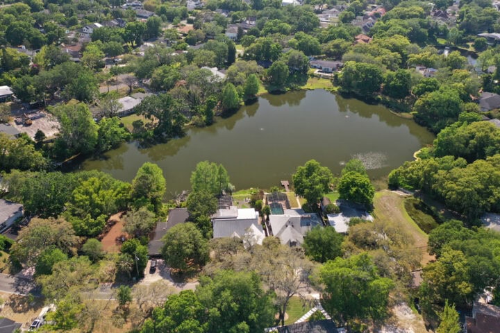
Lake Wilbar
Size 1.1 acres | Drainage Basin 14 acres | Average Depth 5 feet (approx.) | OHW Elevation 87.7 feet
General Information
Lake Wilbar is a small, organic muck bottom, sinkhole pond. The lake receives water from groundwater seepage, and three stormwater outfalls. Water leaves the lake during high water conditions through a culvert to Lake Knowles. The land between the lake and Wilbar Circle is a city park.
Water Quality
Water quality in Lake Wilbar is primarily affected by stormwater runoff. Annual average Secchi disk transparency data from 1997 through 2008 show a slight apparent trend toward lower water clarity.
Management Efforts
The city maintains leaf traps on all four stormwater outfalls to Lake Wilbar. An aeration system has been installed to reduce the frequency of filamentous algae blooms. Lakes division crews also maintain native plant stands around the shoreline to enhance water quality and wildlife value.
Access lakes data dashboard and select Lake Wilbar
Racquet Club Pond
Size 1.4 acres | Drainage Basin 4.3 acres | Average Depth 6 feet (approx.) | OHW Elevation not determined
General Information
The unnamed pond north of the entrance to the Winter Park Racquet Club has two stormwater outfalls discharging to it. One drains water from the racquet club’s retention pond, and the other from the neighborhoods to the east of Via Tuscany. Water is automatically pumped from the pond during high water condition to Howell Branch Creek by a permanent underground pump station.
Water Quality
The largest factor affecting water quality in this pond is stormwater runoff. Annual average Secchi disk transparency data from 1998 through 2008 show a positive statistical trend toward improving water clarity.
Management Efforts
The city maintains leaf traps on the two stormwater outfalls to the pond. An aeration system has been installed to reduce the frequency of filamentous algae blooms. Street improvements included curbing to help channel water to the trap structures rather than flowing over the banks of the pond. This was done to reduce bank erosion and turbidity and sedimentation within the pond. Lakes division crews also maintain native plant stands on the eastern shore along Via Tuscany.
Access lakes data dashboard and select Racquet Club Pond